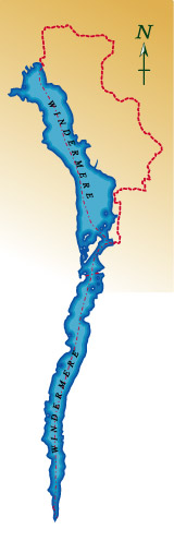
Bowness to Ambleside
Distance 9.75 miles Time 4 – 5 hours
Bowness is the Lake District’s honeypot. Walkers might not immediately feel at home in the bustle of Bowness promenade on a sunny day. Rest assured, a few mintutes walking and we’ll soon be at the lake shore and on our way to Ambleside.
The walk starts at the steamer pier on Bowness Bay and heads north along the promenade and through the village. This initial section is on the road but don’t worry, it’s not for too long. At the mini roundabout take the left fork (Rayrigg Road) and the village is soon left behind. The lake is close by but the high wall of Rayrigg Hall obscures it from view for most of the distance. After half a mile, a permissive footpath on the left leads across a field and down to the lakeshore.
This area is known as Millerground and is a popular spot with both locals and visitors. Turn right and follow the lakeshore north for a quarter of a mile till you reach Millerground Cottage. This National Trust property used to be a ferryman’s cottage and a ferry once operated from here to the opposite shore. A bell was used to summon the ferryman and although this has long gone, it’s housing can still be seen on the gable end. The narrow clinker built boats drawn up on the shore are mostly char boats, used by fishermen to catch this local delicacy. You have to be up very early to see them out on the lake.
You can if you like climb the small hill behind Millerground to get your first view along the north basin of lake Windermere. This is also owned by the National Trust and is known as Queen Adelaide’s Hill after a royal visit many years ago.
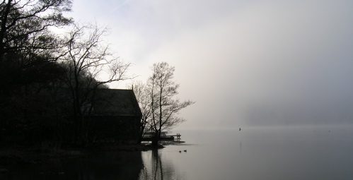
Misty morning at Millerground
The path leaves the lake here and makes for the hills. In contrast to Bowness, it is possible to walk right through Windermere Village on footpaths. Passing a delightful waterfall, the path regains Rayrigg Road. Cross straight over and pick up the footpath opposite. This path is contained by high hedges and walls and leaves you wondering where you are going but after a short distance it comes out by St. Mary’s church on the A591. Turn right and walk up this road for 350 yards and cross over opposite the imposing Windermere Hotel. If you are arriving by bus or train, this makes a convenient starting point for the walk.
A minor road just to the left of the Hotel is signposted Orrest Head. This is a private road but leads to a footpath that finally attains the summit of Orrest Head. There is a panel on the summit that describes the view northwest to the higher hills. It was this view that inspired A. Wainwright so much on his first visit to the Lakes. Rest a while and contemplate the view north and south. This is one of the few points on the walk from which you can see virtually the whole of Windermere and therefore most of the Windermere Way.
There are few access points to the shore on this section, so rather than fight the traffic on the main road, the route stays well away from the lake and in doing so affords some splendid views of the Lake and also of the fells beyond. Leave Orrest Head by taking the path to the north and follow this across fields to a minor road. Turn right and after two hundred yards, take the first footpath on the left, signposted Far Orrest. Follow this well marked footpath across the fields. The path goes through several kissing gates, passing Far Orrest, on the right. Immediately past the farm, cross the grassy lane and follow the signpost marked Crosses Farm. Descend through a small field and at the next signpost turn right for Troutbeck. This path joins a metalled road, through Holehird estate which is followed to a minor road. Cross over and proceed between the barn and cottages opposite. This path leads to the A592, Kirkstone pass road.
Cross the A592, turn right and continue north for 350 yards till a gate leads to a bridlepath descending to Trout Beck. Cross the beck by the footbridge and climb the path on the opposite side.
Windermere Youth Hostel is about half a mile down the road.
Continue across the minor road and climb the path ahead to a second minor road. Turn left along here and after about 100 yards, turn right up a stony track. At the top turn left. This is Robin Lane an old drove road between Troutbeck and Ambleside and the probable route of the Roman road linking the fort at Galava with Penrith via High Street.
A stone pillar on the fellside above the track is not a cairn, but one of several ‘stations’ built by Thomas West to accompany his ‘Guide to the Lakes’ first published in 1778. There were several of these stations dotted around the area and the readers were invited, having climbed to this point to place their guidebook, open at the appropriate page one assumes, on the stone lectern where a diagram of the view would be laid out for them.
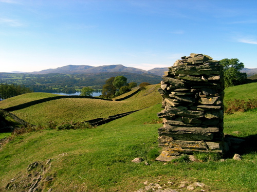
West’s Station
At the next fork in the path take the right turn up Hundreds Road and follow this till it does a U turn at an interesting waterfall. A permissive path (not shown on OS maps but sign posted on the ground) leads off to the right here and heads for a stile in the wall. Wansfell Pike, our next summit is on the left and although it might seem shorter to take the direct route, it really isn’t worth it. Cross the stile and follow this path and when it joins a more obvious path heading up to the top, turn left through the gate. This is one of the paths that the authorities have spent some time repairing in recent years and unlike some of the paths on the higher fells, whoever was responsible made quite a good job of it.
This is the high point of the walk 484 metres (1475 ft in old money). Enjoy it. From here it is all downhill, at least till Ambleside. Descend the steep northern side of the hill. This path has also been paved for most of it’s length. Care is needed as some parts have been left rather poorly finished although on the whole it is quite good. When the path joins the road in the valley, turn left. After 250 yards look out for an old iron turnstile, set back from the road which gives access to Stockghyll Force. A path descends either side of the falls and rejoins the road just before it enters the village.
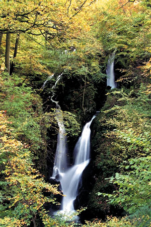
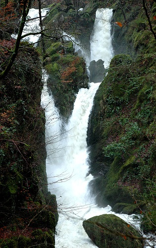
Stockghyll Force in Summer and after heavy rain (courtesy Emma)
There are many excellent hostelries in Ambleside and if breaking your journey here, and returning to Bowness, walk south through the village for just under a mile for the Steamers or alternatively a bus service operates back to Windermere. Accommodation is widely available and Ambleside Youth Hostel is just a few metres from the pier.